Been There Done That But Not Yet

Missing from my visits to major Civil War battlefields is the Battle of Chickamauga on the Georgia / Tennessee state line at Chattanooga. It lies along my intended route north and is on my “must see” list during the return ride from Florida.

Rather than make a “b-line” to the Chickamauga Battlefield, as well as Lookout Mountain and Ruby Falls, two other nearby considerations, I might first meander north into the Smokey Mountains and take a ride down the “Tail of The Dragon”, a renowned motorcycle experience touting 318 curves in 11 miles. I partially assume, based on what I’ve read and heard, it is reserved only for those knee-dragging-curve riders who give rise to the term “crotch rocket”, the purpose of the ride being to see how fast you can make it through the curves and to the bottom of the steep mountains.  A laid back Harley rider such as me might not be welcome, or even allowed to stroll through those curves at a reasonable yet impeding speed. On the other hand the map tells me it is a public road open to anyone with a driver’s license, cars and motorcycles alike. I’ve even seen pictures of trucks with semi-trailers rounding those hairpin curves, taking up the whole road and obviously a hindrance to record-busting daredevils.  It certainly isn’t a priority that I veer off course a hundred or so miles to “Deal’s Gap”, Tennessee, the apparent apex of the dragon's tail, only to backtrack to Chattanooga, but it’s of considerable consideration.

The purpose of staying a northerly course from Georgia, rather than continuing a perimeter of the country, is two-fold. First, I’ve already been to the crowded, time-consuming and expensive East Coast. It was great. Again, if time and money weren’t an issue I’d do it again.

Second, is my quest to whittle down the number of states I’ve never been in, Florida being one of them. After adding Florida to my “been-there-done-that” list, there will remain 9 states I’ve never been in – Alaska, North Dakota, Minnesota, Wisconsin, Michigan, Ohio, Indiana, Delaware and Rhode Island. My intended course will take care of Indiana, Ohio and Michigan. Taking a left turn at Michigan will take me across Wisconsin, Minnesota and North Dakota. The other three states will just have to wait.

Sherry and I might see Alaska someday but doubt we’ll see Delaware or Rhode Island, two states we were within a stone’s throw of back in 2000 but never crossed the line. We almost missed New Jersey also, but spent about one minute in the state when we overshot Port Jervis, New York while seeking lodging at the end of a long day. Upon seeing the sign, “Welcome To New Jersey” we realized we went too far and turned around. But we did cross the line and can therefore include New Jersey on the states we’ve been in list.

Hopefully, Chattanooga will be the last big city I’ll have to put up with for a while. I plan to stick to backroads and small towns as I snake my way north through the foothills of the Smokies. Smack dab along the route is an attraction I hadn’t thought of before but looks like an excellent point of interest to include —“Mammoth Caves National Park”, an experience that should be akin to Carlsbad Caverns. If I recall correctly, I think the 1950’s movie about Tom Sawyer included filming in those caves?  

I visited Abraham Lincoln’s birthplace outside Hodgenville, Kentucky back in 2001. What I failed to realize at the time was that only a few miles north is the burial place of my 5th great grandfather, Thomas Newman, a revolutionary war soldier awarded land in Kentucky, a common payment to veterans of the war. Thomas Newman expanded his Kentucky holdings to more than 700 acres along Lick Creek east of Bardstown before his death and burial in what “was” the Harned-Newman Cemetery about a half mile east of the unincorporated settlement of Boston, Kentucky on Old Boston Road.

Like his son, Isaac, whose grave I found in the obscure Newman Cemetery in Muhlenberg County, Kentucky in 1998, I’m guessing Thomas’s grave and the whole Harned-Newman Cemetery is lost to time and is on private property.  In fact, I’ve checked the street view in Google Earth, inspecting the reported location of the cemetery and there is nothing but a grassy field to be seen. Nevertheless, it is important to me to stand in the vicinity and mentally drink in its history. I'll seek lodging in nearby Bardstown.

Though not a big city by any means, history-rich Bardstown is the seat of Nelson County and only 40 miles from the metropolis of Louisville where I might be forced to find a Harley Shop for a rear tire change, undoubtedly due by then if not before. A 5,000 mile service might also be in order.

I'd never heard of Washington, Indiana before but it’s my next stop after Bardstown. Another Navy buddy I reconnected with after 40 years, via the Internet this past year, has lived his whole life in Washington, Indiana and I intend to pay him a visit.

Continuing north in Indiana, I’ll skirt south around (avoid) Indianapolis and eastward to the border of Ohio, thereby including it on my list of visited states, albeit the visit will be short and just across the state line at Fort Recovery. I could stay in Ohio long enough to meet another guy from my Navy days who lives in the Cleveland area, but that's 230 miles east of my route and against my rule of avoiding freeway mazes in big cities. But I'm sure I would enjoy a visit with him.

The significance of stopping at Fort Recovery? It is where Sherry’s 5th great grandfather, Inslee Anderson, age 32, was killed in a 1791 Indian battle known as St Clair’s Defeat. Miami Indians under the command of Little Turtle annihilated U.S. Army troops under Major General Arthur St. Clair who was on a presidential mission to protect settlers who were oozing into the wilderness after the American Revolution. Major "Mad Anthony" Wayne was sent to pick up the pieces and ordered a fort built on the battle site, appropriately naming it "Fort Recovery." A mass Indian attack was launched against the fort in 1794 but was successfully repelled and led to defeat of the regional tribes. I don’t expect to find much at Fort Recovery, except a monument where perhaps Inslee Anderson will be among the engraved names.

I struggle to find logic in my intent to travel up the Michigan peninsula and across the 7-mile-long Mackinac Bridge that divides Lake Michigan and Lake Huron. That entire region looks fraught with freeways and mass population, reducing the likelihood of my sticking to backroads. Wading through all that is merely for the sake of adding Michigan to my list of states visited. An alternative would be to merely cross the Michigan border to satisfy the list, and then set a westward course below the Great Lakes.  But that would take me through Chicago, not a desirable alternative. Then again, I could swing south and bypass Chicago, although that hardly seems practical if I want to access Wisconsin and Minnesota. Nope … crossing the Mackinac Bridge seems less illogical. Besides, once across that bridge, the road west looks as if it might have minimal population (my preference) and remain for the rest of the trip.

I have no idea of what to expect from Wisconsin and Minnesota, and I don’t anticipate a comfortable experience crossing North Dakota, much less any points of interest other than Fort Abraham Lincoln near Bismarck, a place I do want to visit. Two things I "do expect" while crossing North Dakota, and not in a good way, are desolation and high wind. I hope I don't arrive in the "north country" too early, when winter might still be on the menu. Hopefully, it will be June or close to it before I get to Michigan.

That about wraps up the plan for my pending odyssey. Once I get into Montana I’ll be in familiar territory, having been there several times. Although, not really, not until I get south of Great Falls and near Missoula. From there it will be "homeward bound" and I should be able to do it with my eyes closed.


The Road North (Click Image To Enlarge)


Turn Left At Michigan


Anticipated Points of Interest:


Camera Test

Yesterday being a dry but "unfrozen" day, I mounted my never-before-used "GoPro" video camera to the Harley's crash bar and took a spin around town. The default resolution is 1440 at 48 frames per second. I'm not sure if that frame count is what makes me look like I'm traveling about three times as fast as I actually was?  Honestly, I wasn't speeding.

In rendering a video for online upload the resolution is cut in half, diminishing the quality and that is noticeable in the shimmering edge affect, such as the powerlines and bottom edge of the motorcycle fender. The camera did fair going against the sun and shows great color in side angled sun and when the sunlight is coming from behind.

I hope to make good use of this camera on the upcoming Florida Ride, although I might have to rethink my mounting options. The mounted camera can be seen in the motorcycle's shadow shown in the video. At each end of the "stem," on top of which the camera is attached, is a ball-joint connection allowing unlimited rotation of the stem and camera. I have the stem positioned vertically to prevent obvious "sideswiping" of objects in close quarters. In actuality, the camera could be mounted on the horizontal portion of the crashbar but would need a shorter stem, which is probably what I should have bought in the first place. Naturally, all the acessories are sold separately.

I am also experimenting with the video website "Vimeo" to house online videos as opposed to the traditional Youtube. Although the "free" use of Vimeo only allows one video per week (seems to take me that long to upload one anyway), and I don't like the seemingly permanent display of the smiley face and file name when the video is at rest, it still impresses me more than the smaller blog display of Youtube. My main complaint about Youtube is the checkerboard of advertised videos that pop up at the end of your video, and you never know what those might be. Some are pretty crude.


On The Street in Oakridge (Jan 24, 2013)


Florida Or Bust

My ride to Florida will involve an early to mid-April departure to get there before the weather gets nasty. I’m told arriving there in the summer as I’d first thought (my inclination because I always try to leave Oregon in good weather) is a mistake. It’s extremely hot, muggy and hurricane season actually starts in June, not in September as I’d previously thought. It’s questionable but possible to find a decent April day to leave Oregon and find good weather left overs in Florida, but that means crossing Texas in tornado season. I’ll have to risk it.

Another Texas dilemma is the opposite directions where lives two of the three people I’d like to visit while passing through the state.  How to do it without wasting miles and time? Two cousins live in the Dallas area and a Navy buddy I haven’t seen in 40 years, but have had recent contact with, lives near San Antonio.  Maybe I’ll go to San Antonio first and from there straight up to Dallas, thereby avoiding the dreaded Houston congestion on the eastward route from San Antonio. Not wanting to negotiate Dallas freeways any more than Houston, I’d stop shy of the city at the suburb of Lancaster, a place of historical interest to me.

My great-great grandfather, Charles Horatio Bernard, arrived in the area of Lancaster in 1846. He, his wife, and a smattering of cousins, migrated there by wagon train from Adams County, Illinois. My great great grandparents are buried in the nearby Rawlins Cemetery. The Rawlins and Bernard families mixed by marriage so I’m related to a few them as well.  At Lancaster I’d be close enough to visit some live cousins in the Dallas area, one of whom also rides a motorcycle and might like to accompany me to the Louisiana state line, showing me the much preferred backroads.

If I linger in Texas it will obviously take longer than 8 days to reach Florida, which is what I originally planned based on 300-to-400-mile-per-day “freeway” travel. With these adjustments I should plan for at least two weeks getting there, especially if I’m stopping to take pictures along the way, which most assuredly I will.

In order to maintain this blog and store the numerous pictures, it will be essential I take along my laptop and seek motels offering “wi fi”. That might prove difficult in my quest for backroad travel where even lodging itself might be scarce, much less motels with Internet service. Packing a laptop in my limited space won’t be desirable but it’s becoming apparent I’m addicted to the device and will have to make room.

Weather wise it behooves me to seek a southern route as soon as possible upon leaving Oregon in early spiring, which will mean traveling down Interstate 5 in California. Once south of Redding any snow-threat should be nil. The trade-off will be having to contend with heavier traffic, in particular the congestion of passing through Sacramento. I plan to avoid Los Angeles entirely by cutting east at Bakersfield, up and over the Tehachapi Pass to Barstow and Needles where I hope to spend my second night.

The first significant stop on the trip will be a visit with my daughter, Charlotte, and her family at Cave Creek, Arizona, which thankfully sets on the northern outskirts of Phoenix. Leaving Cave Creek I plan to skirt around the east side of the big city and angle into a mountainous region leading to Globe, then angle southeast to Interstate 10 that will take me all the way to Van Horn, Texas where I will leave the freeway, angling down to San Antonio. A hiccup will show on my cross-country map as I shoot straight up to the Dallas area, only to return south before leaving Texas entirely.

Preferably, I'll stick to the backroads into Louisiana, Mississippi and Alabama before entering Florida east of the busy Pensacola area. On the other hand, a return to Interstate 10 might be the choice if those backroads between small towns with sparse lodging aren’t to my liking. Past experience reminds me loose-running dogs are commonly allowed in the rural south, not to mention the added hazard of deer crossings in the backwoods. High speed hazards of freeway travel might be safer after all, not to mention the better selection of motels. Another consideration is a route south of Interstate 10, right on the water, though close study suggests heavy congestion, especially east of New Orleans. Nevertheless, if time and money were no problem it would be enjoyable to stay along the waterfront.

Florida being the focal point of the trip, I would like to take my time traveling to the southern tip of the state and meet three cousins who are scattered along the way. I've never met any of them but we've communicated for several years on the Internet concerning our mutual interest in genealogy. The first one lives in the relatively small town of Bell. After a brief visit my interests will take me an hour or so east to the historical “Cross Creek”, made famous by the “The Yearling,” a 1938 novel by Marjorie Kinnan Rawlings (and 1946 movie) who lived at Cross Creek, a virtual wilderness at the time. She based her story on the people and surrounding landscape. A 1983 movie, “Cross Creek”, starred Mary Steenburgen as Marjorie Kinnan Rawlings and was partially filmed in the area. Since seeing that movie I’ve had a hankering to see the place for real.

Florida Cousin #2  (“Ralph”) lives east of Tampa in the town of Thonotosassa, my next stop. We’ve discussed my pending visit for quite some time via email and are both looking forward to finally meeting one another. Ralph might show me some of the local points of interest.

Along the route from Tampa to Key West is Everglades City. I hope to spend at least one night there, in what looks like a small, lodging-scarce town at the edge of Everglades National Park and undoubtedly where reservations are a must. If I'm lucky I might even go on one of those air boat rides.

I’m not expecting much from a visit to Key West, having heard accounts of it being very crowded with high dollar lodging and a fair share of debauchery, none of which is appealing. Yet I’m also told one cannot consider a Florida visit complete without a trip to the famed Key West.  It should be a unique ride along those long stretches between the keys. I expect I’ll enjoy that and, if I decide to spend the night, I might get a good “sunset” picture. Once the “Key West Mission” is complete, I’ll set my sights north to the east coast town of Edgewater, near Daytona, where lives Cousin #3.

Miami looks to be the “mother of urban spread” and I have absolutely no desire to ride through its maze of freeways. I will do whatever it takes to find a rural route bypassing its west side, though I realize I can’t avoid heavy traffic entirely in Florida. Somewhere north of Miami, Fort Lauderdale and West Palm Beach, I’ll connect to Interstate 95 and ride it as far as Jacksonville where I’ll cut inland on Interstate 10 to Interstate 75 and up to Georgia.


Travel Route Made With Google Earth (Click To Enlarge)
 

Ready To Ride

I’m 62 years old ….. but that won't last long. As my life ticks away with no adventures on the horizon, I ponder the possibilities. I’ve always enjoyed road trips on a motorcycle and have been on many, the highlight of which was the USA Ride in 2000, the year I retired. My wife, Sherry, and I rode our 1998 Harley Road King to Maine and back. It was an adventure that continues to bring good memories and a yearning to do it again.  I am hoping to complete one more “big ride”, this time to Florida and back. I’m hoping the ride will commence in April when the snow has melted from Oregon’s mountain passes.

Though she’s always invited, Sherry encourages me to go alone. Being immersed in her own hobbies at home, which centers around her horse and our three dogs who need constant care (and let's not forget the two cats and "Arlo" the parrot), she doesn’t share my zeal to leave it all and freely roam the country. She also agrees I need some spark back in my life. It’s like when Billy Crystal went on that cattle drive in the movie, City Slickers. She knows I need to do something to put a smile back on my face. And so it is. I’m in the planning stage of the trip and am using Google Earth to map out a strategy.

The interesting part of this ride won’t start until reaching Florida. I feel it prudent in early to mid-April to take the snow-free southern road, a long and boring crossing of the Southwest I’ve traveled several times before and recall nothing of interest to look at. For that reason, and because lodging expenses are what they are in this day and age, I plan to get at least to the middle of Texas before slowing down. Not that west Texas has much in the way of scenery but it is where lives an old Navy buddy and a couple of cousins I would like to visit. As I linger there I’m hoping springtime tornadoes stay in Oklahoma and Kansas.

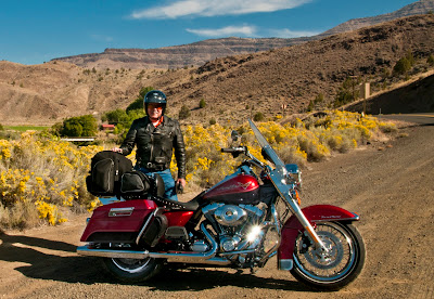
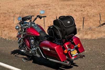
Because I usually record my travels in a journal (the 2000 USA ride generated 268 handwritten pages) I will take my laptop and “blog” my observations and photos whenever “wi fi” is available. To become familiar with the process I will make this my first entry and use the blog to record the trip planning, and perhaps include relevant photos from time to time. Of course most relevant will be a picture of me and my ride, a 2012 Harley Davidson Road King. These two photos were taken during an Eastern Oregon Ride last September:


Near Cathederal Rock South of Kimberly, Oregon (Sept 2012)


U.S. Hwy 395 South of Long Creek, Oregon (Sept 2012)